CRWD surpasses flood-reduction goal

Five years ago this month, local leaders met at the confluence of the Cedar River and Dobbins Creek to announce a $3.2 million grant for improving water quality and reducing floodwaters.
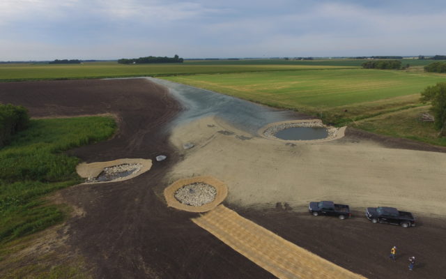

Today, CRWD has surpassed that goal by achieving at least a 10-percent peak flow reduction at the Cedar-Dobbins point now that construction has finished on creating the district’s biggest project to date – Dexter 30-Dam 2. Spanning nearly 2,000 feet long with a peak berm height of 21 feet, the $1.2 million structure in Dexter Township now is fully functional for temporary storage of stormwater in the headwaters of Dobbins Creek’s south branch.
CRWD’s goal for its Capital Improvement Plan (CIP) was achieved with $6.6 million in funds from The Hormel Foundation and state and local resources, with 14 projects built, including 11 upland-storage structures in the Dobbins watershed mostly built on streams flowing into the creek’s north and south branches. Nearly 3,000 acres overall now are controlled by CIP projects in the Dobbins watershed prone to flash flooding.
With all CIP projects in place, a 10-year rain storm (roughly 4 inches of rain) – which leads to some rural roads being overtopped by flooding – would be about 1 foot lower at its peak downstream from Dobbins Creek’s confluence of its north and south branches in the Jay C. Hormel Nature Center.
CRWD is hoping for a special session of the Minnesota Legislature yet this year to pass a state bonding bill that includes about $500,000 for additional flood-reduction projects under the district’s CIP initiative.
With a heavy focus on the Dobbins watershed prone to flash flooding, the district’s CIP projects have drawn the interest of the National Weather Service out of LaCrosse, Wis., after staff there recognized that a flood gauge on Dobbins in Austin was not reaching levels that it normally would during rain storms. National Weather Service is reviewing CRWD’s data to determine if its flood modeling needs to be updated to account for the positive effects of the district’s projects.
With the latest project – the only one planned this year – and another project finished in 2019 just upstream from it, CRWD now has two earthen berms in South Dobbins Creek’s headwaters that can slow and treat stormwater coming from 1,240 acres of mostly cropland. The berms can capture enough stormwater to cover an area up to three times larger than Austin’s East Side Lake, a dammed stretch of Dobbins.
When the area gets about 8 inches of rain over 24 hours – roughly what’s considered a “100-year flood” – the Dexter 30 berms will temporarily hold stormwater covering nearly 100 acres or about 2.5 times the acreage of East Side Lake. At capacity, stormwater will cover about 120 acres with enough water to fill a 550-foot-deep pool the size of a football field.
CRWD’s CIP project construction, which started in 2016, has created three structures along the Cedar River State Water Trail in Austin Township and the rest all in the uplands of the Dobbins watershed.
With this system, rain events like the storms that caused Austin’s worst-known floods in 2000, 2004, 2008 and 2010 will have a 10 percent lower peak flow – floodwaters won’t crest as high – where Dobbins flows into the Cedar.
CRWD originally planned for 25 projects with the CIP initiative but, as opportunities have arisen for larger, more-productive projects, the overall value delivered by fewer projects has far exceeded the original plan.
CIP projects are funded by a $3.2 million grant awarded by The Hormel Foundation and nearly another $4 million thus far in funding from state grants and state bonding. Up to $1 million from a CRWD local project levy is available, if needed.
CRWD’s new berm was built just east of Mower County Road 19, a few miles northeast of Interstate 90’s juncture with Minnesota Highway 56. Combined, the Dexter 30 berms should eliminate the threat of stormwater or snowmelt flowing over the downstream section of County 19, which has a history of overtopping often.
Red Rock Township’s 230th Street gravel road that crosses South Dobbins also should see less overtopping now.
CRWD heavily targets the Dobbins watershed due to its history of flash flooding that causes water-quality issues and flood damage to rural and urban infrastructure and properties. Upland water storage is a CIP focus because it decreases the amount and speed of stormwater flow, reducing the potential for significant streambank erosion.
Through the CIP projects’ treatment, much of the sediment, excess nutrients and other pollutants in stormwater can settle to the bottom of the basin created behind the berms rather than continue into Dobbins Creek and the Cedar River. Sediment is loose particles of sand, clay, silt and other substances mostly from eroding soils on land or streambanks that makes streams cloudy, which is harmful to fish and plant life while also filling in lakes and streams.
CIP projects also protect and enhance wildlife habitat through easements that keep land as prairie and wetlands.


You Might Also Like